 Mount Elbert (14,440 ft), Leadville, Colorado
Mount Elbert (14,440 ft), Leadville, Colorado
 |
Journal of a Mad Hiker (Part 1, continued)
| Hike Stats | Date: June 19, 2002 | |
| Mount Elbert: 14,440 feet | Base: 10,060 feet | Vertical Rise: 4,380 feet |
| Start: 07:30 | Summit: 11:15 | Return: 14:00 |
| RT Dist: ~9 miles | Conditions: sunny & clear | |
Mount Elbert is the tallest peak in Colorado at 14,440 feet and the second tallest point in the lower 48 states (California's Mount Whitney is slightly higher at 14,494 feet). The mountain was named for Samuel Elbert, an influential leader in the Colorado Territory who served as Secretary, Territorial Governor, and State Supreme Court Justice in his days. An interesting note is that Samuel Elbert was the son-in-law of John Evans, the second territorial governor of Colorado and for whom Mount Evans was named. Even more interestingly, at the time I hiked it, everyone thought Elbert was only 14,433 feet above sea level. But the latest USGS surveys indicate that Elbert, as well as many other Colorado fouteeners, is actually 7 feet higher! No wonder I was tired!
Mount Elbert is also the main reason for my peak-bagging trip to Colorado. I wanted to hike a few fourteeners, but Elbert was definitely going to be among them! While planning the trip, which consisted of 30 minutes or so of map reading since the trip was a spur-of-the moment decision, I made sure that I would drive past and hike Elbert.
So the trip took shape as it progressed, and I decided to break it into 3 days. Day 1, drive from Phoenix to Telluride. Day 2, hike Mount Sneffels as a warm up and drive to Leadville for Elbert. On day 3, I would hike Elbert and drive to Denver where I'd find a home base for further hikes. The plan executed exceedingly well except a small glitch where the warm-up hike turned out to be much more of an effort than expected.
The night before I was to tackle Elbert, tired from Sneffels and the long drive from Ouray, I sought a quick dinner and an early night in Leadville. Leadville is a decent-sized city that grew from a mining town, and at elevation 10,200, it's probably the highest big city in the country. The main drag offered quite a few choices for food and lodging. I settled for the Golden Burro Cafe and a huge meal of pork chops, washed down with a local microbrew. Just outside the city, Halfmoon Campground offers great camping facilities and easy access to Mt. Elbert and Mt. Massive. Halfmoon Road drove much easier than Sneffels for my poor little 2WD Prizm. I was ecstatic as I drove the graded dirt road without bottoming out!
As luck would have it, I was the only one in the campground, and that made for a wonderful night's rest. The 35-degree morning temperature was a little harsh, but not terribly bad after my blood thawed and started to circulate. I packed up and arrived at the Colorado / Main Range Trailhead at 7:00 am. This trailhead is nicely nestled between Elbert and Massive (2nd highest peak in Colorado) and feeds the Northeast Ridge trail to Elbert's peak.
It must be the altitude, but I was extremely disorganized this morning. I must have locked, opened, and relocked my car 5 times before I got everything I needed for the hike. Even then, I forgot my bottle of Tylenol. I also spent nearly 20 minutes looking for my hat, which I eventually concluded that I lost on the hike up Mount Sneffels. Despite all the troubles, I finally got going about 7:30 and quickly fell into a nice hike zone. I was pleasantly surprised that I felt light and fit after having hiked Sneffels the day before. So I plodded along toward the highest peak in Colorado...
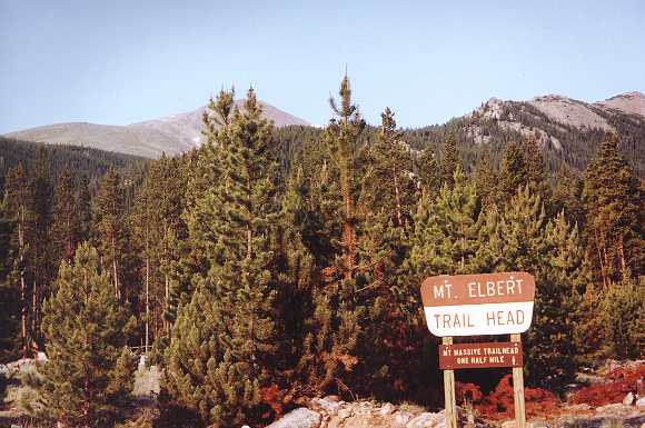
This is the start of the hike at the Colorado / Main Range trailhead. Elevation is 10,060 here. You can just make out the peak of Elbert above the tips of the trees. There are many ways to approach Elbert, and many trails to its peak, but this one is the closest to Leadville and the most convenient in my "grand plan".
 |
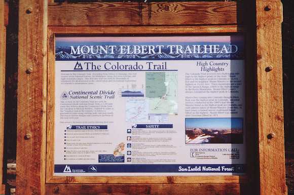
This trail is a part of the Colorado Trail, which is an entire system of trails that runs all the way from Denver to Durango. This plaque at the Elbert trailhead explains its features and benefits. Sounds like a lot of work, but I bet it'd be awesome to hike the whole thing.
 |
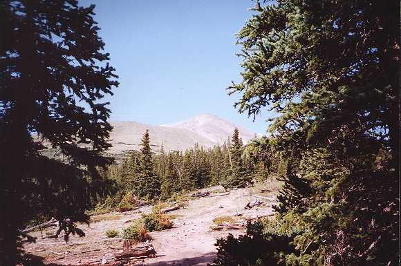
The Northeast Ridge trail runs steady and steep. There were quite a few switchbacks getting from the trailhead to the ridge, but most of it lies in deep pine forest, and it was very pleasant. I hiked a brisk pace, testing my endurance, and came to treeline fairly quickly. This is a shot as I broke through the edge of the forest and looked toward the top of Elbert.
 |
So you want to go to the top? You'll have to get past me first! Just kidding. I'm straddling the well-worn trail in the alpine tundra above treeline. The peak of Elbert is behind me.
You'll note the not-too-attractive-but-infinitely-pragmatic hiking attire. White t-shirt and shorts for comfort, newly acquired (and much appreciated) backpack with chest and waist straps, fanny pack for camera and essentials, broken-in hiking shoes with high-top ankle support, a fresh coat or two of SPF 15 sport sunblock (unfortunately I forgot to apply it to my head on this day), and the ubiquitous 1.5 liter bottle of water. Inside the backpack I had sweatshirt and pants, waterproof windbreaker with hood, emergency ponchos, 3 more liters of water, first-aid kit, topo maps and trail guides, enough food to feed 3 hungry gorillas, T.P., towel, extra socks, and dangling from the pack are my compass and thermometer. Everything a guy could need or want on a hike like this. Made my shoulders sore at the end of the day, but better to be overprepared than under!
 |
Near the summit of Elbert, I paused to look to the north and survey the zenith of Mount Massive. What a fitting name, this thing is truly a monolith.
 |
The trail to Elbert proved gentle and straight. Only one small false peak to speak of. Actually, I was expecting a little more fight out of Elbert. I summitted around 11:10 am and a strong steady wind greeted me. The sky was relatively clear and sunny, but it felt cold with the windchill. I had to pull out the sweatshirt for the victory pose. Fourth 14'er (second solo) conquered.
BTW, you'll see me wear this sweatshirt a lot on my hiking adventures. I got it on Pikes Peak (hence the Pikes Peak logo) after summitting my first fourteener several years earlier. Since then, it's become my favorite sweatshirt for hiking, a kind of mental totem to the hiking gods and a good luck charm to keep me warm and safe.
So, I have a question. Why isn't there a more ceremonious marker for the tallest point in the state? What's with the wooden cross anyway? Is it there to mark the spot where the mountain claimed its last victim? OK, I guess that's more than one question.
 |
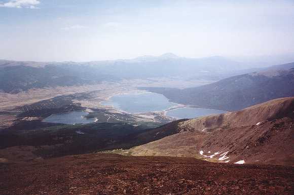
This is a picture looking down and toward the south from the peak. You can see the Twin Lakes community and its namesake bodies of water. BTW, shouldn't it be called Triplet Lakes?
Mt. Elbert Trail, the most popular route up Elbert, begins there. I was originally planning on using that trail for my ascent, but it would have taken a 35-minute backtrack along US 24 from Leadville to get there.
 |
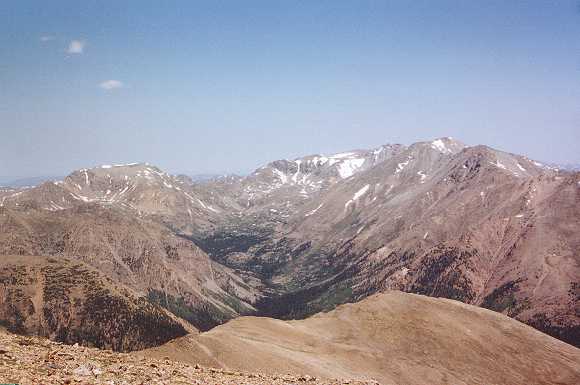
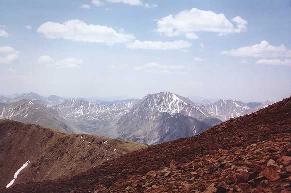
This is a view toward the west at La Plata Peak (14,336 feet), another very tempting peak-bagging target. It'll have to wait until my next trip. You might be thinking now that I'm a little too aggressive on these hikes, and you might think more so after the next two segments in this photo journal. But in actuality, I'm nowhere near the extreme. Just remember, no matter how crazy you or others think you are, there's always someone crazier!
Here's proof. I ran across this online account of the Nolan's 14 where a bunch of nuts (that's the only fitting term I can come up with) race across the Sawatch range and bag 14 fourteeners in 60 excruciating hours! At a distance of 100 miles on foot and an aggregate elevation gain of 44,000 feet, what other word can I use to describe these insane people??
 |
The descent down the Northeast Ridge trail was uneventful, but I did run into someone else from Phoenix along the hike. He was also doing a solo trip through Colorado, but the difference is that he's retired while I, regrettably, have to return to work someday! Can you tell I'm a little jealous?
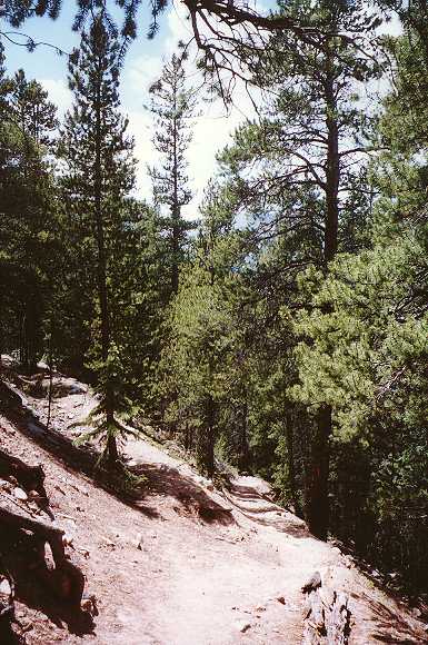
On the way up, I was in too much of a zone to pause and take a photo in the forest. This is a section of the trail just below the ridge line. Once again, the 2D photo destroyed the perspective and depth of the view. The trail is actually quite steep here, much more so than it looks from the photo.
At this point, I realized that I forgot my head when applying the sunblock and got a nasty sunburn. It's one of those "you know...when..." moments. You know you are losing your hair when you get sunburned on top of your head! Fortunately there was a small stream near the trailhead, and I was able to cool off a bit. (QUITE a bit, since the water was about 40 degrees!)
 |
Ah, what a feeling of accomplishment. I had bagged the high point in Colorado. Yes! The main purpose for my trip has been fulfilled, and it's only the second day. Life is good.
I paused in Leadville to buy some souvenirs, and here is a shot of the plaque at the city limits. I thought I might start a collection of fourteener t-shirts as I climb them -- something to remember each peak by. It turns out there's a great little store called Dee Hive in Leadville where they make custom printed t-shirts while you wait. Worth a visit if you end up there.
 |
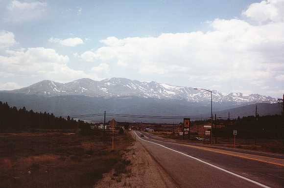
This is a scenic view toward the aptly named Mount Massive from US Hwy 24 south of Leadville. I love how the peak seems to glow while the forested base blends in with the scenery. It makes the mountain top seem to float in mid air. Stunning!
Now it's onto Denver where I'm staying with a friend for the rest of the trip and from where I would venture out and bag four other fourteeners on this trip!
 |
| Prev | Next | Index |