 Pikes Peak (14,115 ft), Manitou Springs, Colorado
Pikes Peak (14,115 ft), Manitou Springs, Colorado
 |
| Hike Stats | Date: May 31, 1998 | |
| Pikes Peak: 14,115 feet | Base: 6,600 feet | Vertical Rise: 7,515 feet |
| Start: 06:30 | Summit: 14:00 | Return: N/A |
| RT Dist: ~26 miles | Conditions: sunny & clear, snow above treeline | |
Ah ... Pikes Peak! This is my favorite hike of all time, even though I had done it only once. It was also my first "fourteener" (peak over 14,000 feet), and it's fittingly so because the practice of "peak bagging" essentially started here with Lt. Zebulon Pike who became the first "peak bagger" in 1806 when he was commissioned by Thomas Jefferson to explore the Lousiana Purchase. Sadly and ironically, Lt. Pike never summitted the mountain that bears his name as he declared in his journal, "I believe no human being could have ascended to its pinnacle." Sorry to disappoint you Zeb, this dude did it.
Pikes Peak is simply the best all-around experience a hiker can expect. The Barr Trail starts in the quaint tourist town of Manitou Springs at an elevation of 6,500 feet, winds its way through scenic forest and alpine tundra, and eventually ends up on a gorgeous snow capped peak of 14,115 feet! No where else in Colorado can you get so much elevation gain in a hike to a fourteener. The average grade from trailhead to peak is 11%!
The town of Manitou Springs (adjacent to Colorado Springs) is surrounded by natural wonders such as Garden of the Gods, Cave of the Wind, and Seven Falls. Time and modern development seem to have passed over this place because it's so well preserved. It's a pleasure to visit even if you don't do anything on Pikes Peak.
The peak itself, the most famous in Colorado (and perhaps in the US), is steeped in tradition and history. First explored by Lt. Zebulon Montgomery Pike in 1806, Pikes Peak proudly guards the skyline above modern day Colorado Springs. For 200 years, people have climbed, hiked, drove, skied and otherwise explored it. The view from its peak inspired Katherine Lee Bates to write the lyrics to "America the Beautiful" in 1893. The world's highest railroad and second highest highway were constructed to reach its summit. There's even an annual auto-race called the Pikes Peak Hill Climb on every Fourth of July and a grueling Pikes Peak Marathon up and down the hill on the very trail we hiked!
For a number of years, I was fortunate enough to work for General Motors, which operates a test facility in Manitou Springs. The brake group comes to Pikes Peak every summer to conduct brake tests up and down Pikes Peak, and I was part of this effort for a number of years. One glorious Sunday in May of 1998, while spending a couple of weeks in Colorado Springs with GM, I was inspired to hike the Barr Trail. Luckily the weather was accommodating that day, and we reached the summit safely and capped off an awesome hiking experience. These photos attempt to capture the events of that day in some detail. Enjoy!
One short week after our annual Grand Canyon hike, my good friend Scott flew up to Colorado Springs on a whim and joined me for this hike. In the early morning daylight (6:30 am), we arrive at the start of Barr Trail, nestled in the woods near the Pikes Peak Cog Railway Station in Manitou Springs. To our surprise, the entire trailhead parking lot was already full. We had to park down by the Railway Station, which technically added another 200 feet of elevation gain to our hike.
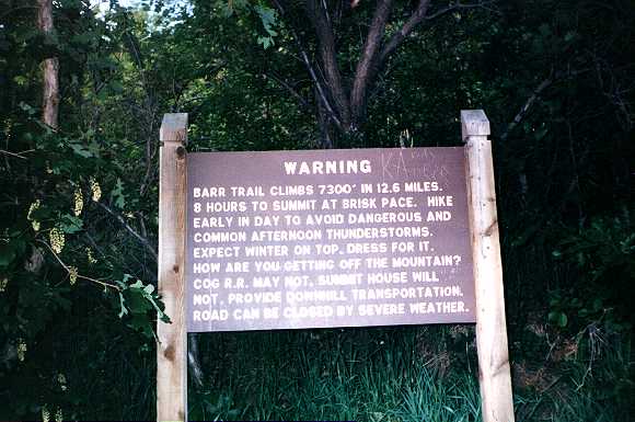
This warning sign sits at the start of Barr Trail, deterring ill-prepared hikers. From many trips to the peak in a brake test car, I can attest to its truth. We've been snowed in at the top in the middle of summer before! The weather at the top is always unpredictable and was our major concern on this day hike.
 |
Coming from the 1,200-ft altitude in Phoenix, Scott and I were winded on the 7,000-ft trailhead nearly as soon as we started. We each came well prepared with 4.5 liters of water, 5 PB&J sandwiches, sweats, rain-proof jackets, and a bottle of Tylenol for the headaches that inevitably plague alpine hikers. We even reserved seats on the Cog Railroad for a ride down, but unfortunately we weren't prepared with a proper estimate of the effort. We've heard everything between 4 hours to 12! This caused us some concern as we hurried our pace near the start, adding to our breathing problems...
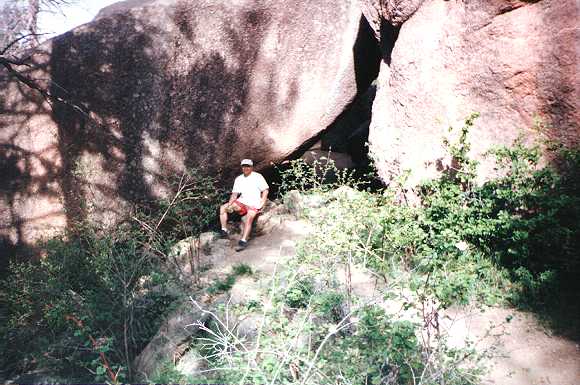
To our disgust, there was a constant stream of people on the trail RUNNING past us while we sat wheezing off to the side! There was even one girl who rode a mountain bike UP the trail!!! Here I am taking one of many rests along the trail, which goes through a natural tunnel formed by the rocks behind me. This is about 8,000 feet in elevation.
 |
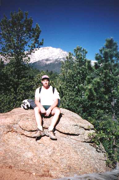
Scott takes a breather and our first food break on a scenic rock with the peak behind us. I'd say we are at about 9,000 feet here. Man, we've got a long way to go! It must have been my reaction to the altitude, but I found that when I was going at a steady pace, I was fine. As soon as I stopped to rest, I got nauscious and felt disoriented.
 |
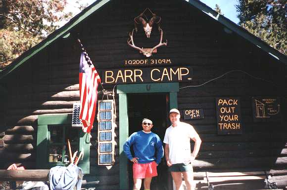
Our spirits improved as we reached Barr Camp in the late morning. As you can see, the elevation is about 10,200 here, and the cabin serves as a refuge for weary hikers. Inside the cabin are rows and rows of makeshift beds, and a small kitchen area. Many people hike to this point and turn back, but not us! We have a mission to accomplish. After a decent rest and lunch, we set off for the top. By now, our lungs have adjusted somewhat to the altitude and the amount of effort we were putting forth. You can say that we caught our "second wind" at this point.
 |
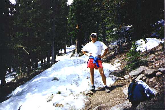
Shortly after Barr Camp, we had our first snow sighting. The trail was covered with snow in places. This was one thing for which we were not well prepared. We had hiking shoes, but they didn't help much as our legs sank into the snow. In some places, we were up to our knees in snow. Here though, it was still sunny and fairly warm, and I was doing fine in shorts and a tee-shirt. The snow still looked like a cool novelty instead of a hinderance. Elevation: about 11,000 feet.
 |
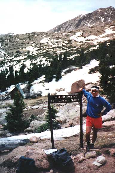
Timberline! We are doing OK on time as I give the thumbs up. There's a tiny shelter here for anyone caught in the frequent storms in the high country. The winds have kicked up without the tree cover, and I'm forced to don the sweat shirt. The altitude here is about 12,000 feet.
 |
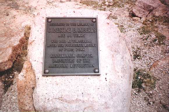
Just above timberline, we found this plaque commemorating one amazing woman who made over a dozen ascents of Pikes Peak. I'd be doing very well to even attempt this hike when I'm 88 (if I'm still around)!
Above timberline, we ran into real trouble. We lost the Barr Trail under heavy snow cover, and were forced to take a line-of-sight approach to the peak -- straight up! At places we were boulder hopping, and at others we were knee deep in snow. The going was getting tougher by the minute.
I also found that above 13,000 feet or so, the altitude really starts to take its toll on one's coordination and sense of balance. Our hands and faces were swollen from the differential between our blood pressure and the air pressure, and the headaches really kicked in despite the Tylenol we had been taking since the night before and at every 2 hours during the hike.
 |
I had to focus on the hike and was too disoriented to take photos above 13,000 feet. All I can recall is that we eventually rejoined Barr Trail as we made a bee-line for the peak. The trail near the top was made visible by the feet of some tourists who drove to the peak and decided to hike a little ways downward. Finding the trail again was a huge mental victory, although we gained the last 1,000 feet or so of elevation by stopping to gasp for air after every few steps.
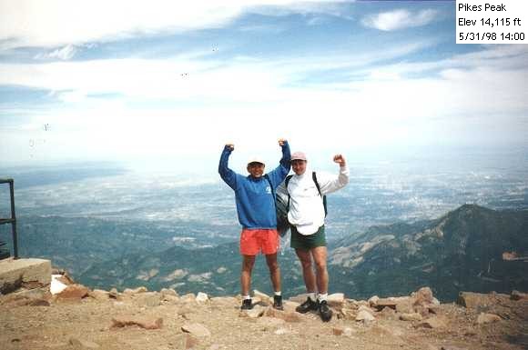
We summitted the peak around 2 pm in a grand total of 7.5 hours. The temperature at the top was about 40 degrees, but it was still sunny. Scott and I stopped for the obligatory victory pose at the end of Barr Trail. YES! We had conquered our first fourteener! Altitude: 14,115 feet.
 |
We had a couple of hours to kill before our train arrived, so we spent that time at the summit house / gift shop / restaurant taking a much deserved rest. The hot apple cider tasted SOOO good that day! We sat with our feet propped up, shoes removed (our socks are soaked by now from all the snow trekking), sipped cider, and watched in amusement as all the tourists who drove up to the top gasp for air with every movement. Our ears were deaf to their complaints! Once in a while, one would glance at our sorry appearances and query about our travails. I distinctly remember the tremendous feeling of accomplishment and pride as I casually replied with a smile, "Yeah, we hiked all the way up here today!"
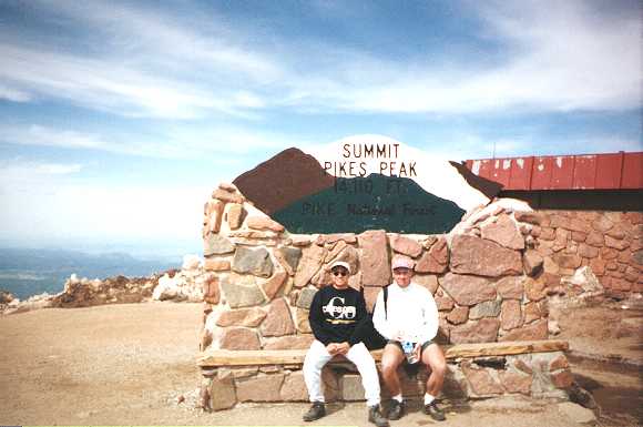
Would you believe that in the gift shop, I could find all kinds of souvenir shirts that say "I survived the drive", "Pikes Peak Highway, no guts, no glory!" with a picture of the paved road on it, but not a SINGLE souvenir shirt with "I survived the hike"? I guess they really want to discourage people from attempting this hike. Oh well, I found a nice "Co" sweatshirt which I'm showing off here at the plaque outside the gift shop. The temperature had dropped to about 30, and my sweat-soaked tee-shirt didn't help the matter. So, I opted for the sweat pants and my souvenir.
The total damage today: 13 miles, 7,500 feet of elevation gain in 7.5 hours!!! For reference, the record on the Pikes Peak Marathon (which is both up AND down on Barr Trail) is 3.5 hours. Now that's FAST!
 |
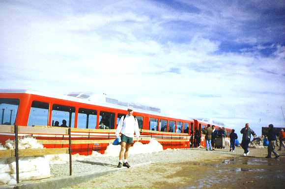
Our train arrived on time to take us back down to Manitou Springs. The Cog Railroad takes a different path than Barr Trail or the paved road, so we got to experience quite a different view. On the way down, we stared with amazement at the peak we had conquered, and smiled to ourselves a lot. Once in a while, we'd catch a glimpse of a marmot or two staring back at us with a confused look. Down in the forest, the railroad runs by a beautiful stream lit by spots of sunshine filtering through the leaves, and some yellow columbine flowers here and there along the stream bed. Yes, this was indeed a very good day, and one I'll remember for a long time. Pikes Peak is definitely the best hike I have ever done!
 |
| Prev | Next | Index |