 Mount Bierstadt (14,065 ft) and Mount Evans (14,265 ft), Georgetown, Colorado
Mount Bierstadt (14,065 ft) and Mount Evans (14,265 ft), Georgetown, Colorado
 |
Journal of a Mad Hiker (Part 1, continued)
| Hike Stats | Date: June 21, 2002 | |
| Mount Bierstadt: 14,065 feet | Base: 11,650 feet | Vertical Rise: 2,415 feet |
| Start: 07:00 | Summit: 09:30 | Return: N/A (to Evans) |
| Mount Evans: 14,265 feet | Base: from Bierstadt | Vertical Rise: ~1,000 feet |
| Start: 10:00 | Summit: 13:20 | Return: 16:30 |
| RT Dist: ~12 miles | Conditions: hazy, windy, and cold | |
My peak-bagging saga continues with Mount Bierstadt and Mount Evans. I chose Evans primarily because it was one of the few I had heard of. Bierstadt was a nice bonus since it was so close that I can do both in the same day. A little history about these peaks... Mount Evans was named for John Evans, the second territorial governor of Colorado who served from 1862 to 1865. He had a keen interest in exploring and mapping the Colorado territory. Mount Bierstadt (no silly, it wasn't named after a "city of beer" as its German name implies) was named after Albert Bierstadt, the well-known painter of western landscapes. His painting of Longs Peak hangs in the Denver Public Library. An interesting fact is that Bierstadt was one of the first known climbers of Mount Evans and his namesake peak. He originally named Mount Evans, the taller of the two peaks, Mount Rosalie after his wife. (Awww, how sweet!) Its name was changed to Evans in 1870, and a nearby peak was named Mount Rosalie.
After the Elbert hike on Wednesday, I headed for Denver to establish a home base. From there, I would venture out again and capture 4 more peaks, but only after a much-deserved rest. As it turns out, a storm system rolled through on Wednesday night and Thursday afternoon, so I couldn't hike anyway. I spent the time visiting friends and taking a short trip to Estes Park, a scenic town on the edge of the Rocky Mountain National Park. While there, I was able to purchase a Longs Peak souvenir or two to make up for the fact that I didn't get a chance to do so after the hike in 1998.
On Friday morning, I ventured out bright and early toward Mount Evans and Mount Bierstadt, full of steam and ready to tackle my first double-peak hike. I had studied the book carefully and plotted out the ideal route to bag these two peaks: start at Guenella Pass, hit Bierstadt, traverse the Sawtooth Ridge, bag Evans, and return around Spalding via the Willows. Well, you know what they say about the best laid plans o' mice and men...
One note about driving a significant distance to the trailhead before the start of a fourteener hike, it slows you down mentally and physically. I didn't feel as good on this hike as on Elbert or Sneffels. It took about an hour to drive from Denver to Georgetown and then up the dirt road to Guanella Pass. That, on top of getting up early and coming from about 5,000 feet elevation to 11,650 feet where the trailhead is, made me a little sluggish. Nevertheless, I was excited to be back on the trail again.
When I started this trip, the news was flooded with stories about the Hayman fire near Denver. Photos and videos screamed for attention on national news. Some of my friends were worried that the trails would be closed. The thought had also crossed my mind, but I checked all the sources and was assured that while fire restrictions were in place, most trails were still open. The last two hikes were in sunny and clear weather, with no sign of the big fire to be found. Today though, I could definitely see the effects of this big blaze. The entire area was covered in haze frome the smoke. I can taste the burnt timber with every breath. It wasn't thick enough to deter me from the hike, but you are constantly reminded that it's there. So onward I go in the misty haze toward peaks #3 and #4 of my trip.
The dirt road from Georgetown to Guanella Pass was long, but not really in terrible condition. Compared to the well graded Halfmoon Road to the Elbert trailhead, it was rough but not impassible. The Prizm held together nicely, even after bottoming on a nasty rut around a hairpin turn, and made it to the trailhead by 7 am. It was markedly cooler this morning after the rain the last few days. I had to start the hike with sweats on. This is a picture of the sign at the Guanella Pass trailhead.
 |
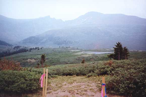
In the early morning sun and haze, you can see in the distance Mount Bierstadt's peak (right) and the aptly named Sawtooth Ridge. The peak to the left of the Sawtooth is Mount Spalding, and Mount Evans lies directly behind it. The green area in the foreground is the infamous Willows, a large open marsh separating me from the summits I seek. It gets the name from the thick willows brush that grow abundantly in this area. They root in the thick quagmire and prevent the marsh from drying up. Who would have thought you'd find a marsh at 11,500 feet elevation?
 |
The trail through the marsh toward Bierstadt was very passable. Apparently someone was nice enough to build wooden boardwalks over the messy areas. I made excellent time up this trail and quickly neared the summit. This shot was taken looking back toward the northwest. The smoky haze is clearly visible.
 |
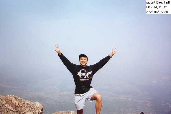
The obligatory victory pose at the summit of Bierstadt. I was in good spirits here and met only a few people up here. One of them had traversed the Sawtooth Ridge toward Evans several times before and was able to give me some much appreciated pointers on the best route to take. So after a brief 30-minute rest and chat with the summit dwellers, I took off along the Sawtooth.
 |
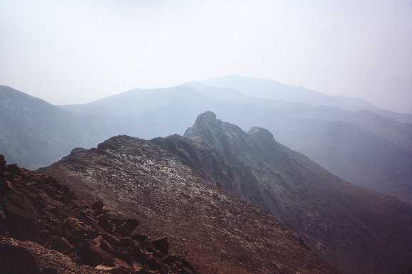
Here is a picture of the Sawtooth Ridge going toward Evans. It is rated a class 3 climb and "advanced" in my book so I had a healthy respect for it. The trickiest and steepest part is the tall section from just past the second notch to the top of the ridge. In retrospect and thankfully, it wasn't as bad as I had anticipated.
 |
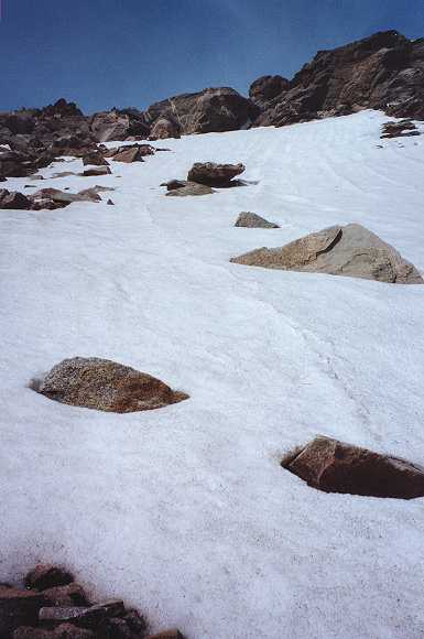
A snow field I encountered along the way down from Bierstadt. It was more of a curiosity than a hinderance. We don't see a lot of this in Phoenix! (OK if you insist, we don't see ANY of this in Phoenix.)
 |
I have an annoying habit. Whenever the trail gets difficult or strenuous, I forget to take photos. When trying to recall the trip as I am doing now putting this story together, these are the parts that I wished I had documented better. Next time, I'm just gonna have to make a better effort to stop and take better pictures.
So the hike above the Sawtooth Ridge was strenous for me. For one thing, I didn't set my expectations properly. In my mind, the Sawtooth is the toughest part of the traverse toward Evans. In actuality, the flat ridge above it was just as difficult. It was long and had a decent elevation gain to it. The wind had also picked up, making the hike that much more difficult.
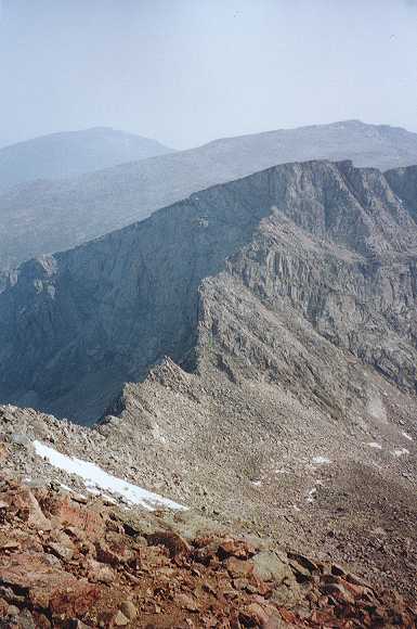
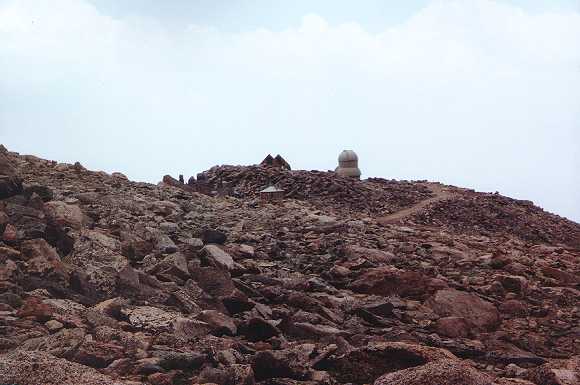
Finally after what seemed like an hour of boulder hopping and ridge walking, I caught my first glimpse of the top of Evans. The dome you see is the Meyer-Womble Observatory built by the University of Denver. Until 2000, it was the highest operating observatory in the world, but unfortunately is not open for visits.
 |
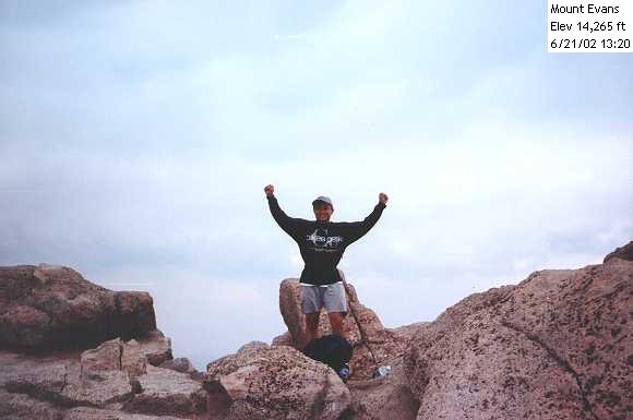
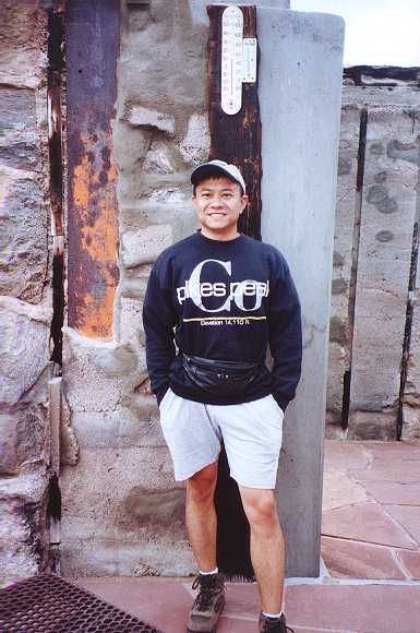
Boy is the wind cold right here! Quick, take my victory pose picture and let's get outta here. Fourth fourteener on this trip bagged!
 |
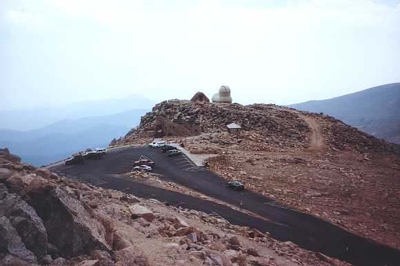
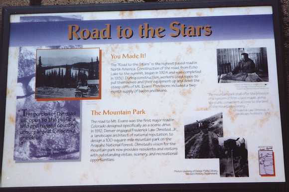
Mt. Evans has the distinction of having the highest road in North America running to a few feet of its peak at an elevation of 14,265 ft. Now before fans of the Trail Ridge Road (Rocky Mountain National Park) get in a tizzy, the Mt. Evans Road (also Pikes Peak Toll Road) is higher, but it's not a continuous road. Once you get to the top, you have to turn back. At one time, this road was going to be part of a peak-to-peak highway system, which was never finished.
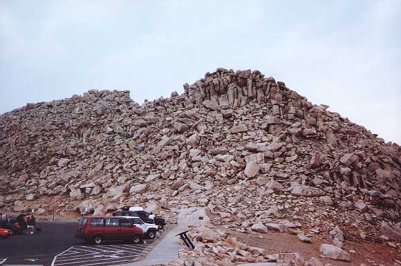
This is a shot of the parking area on top. Unlike Pikes Peak, there isn't a gift store or restaurant up here. Well, actually there was at one time. A restaurant and gift shop was built here in the 1940s and was the highest store in the world, but a propane fire destroyed it in 1979. Too bad, I really could use a steaming cup of hot chocolate right about now.
 |
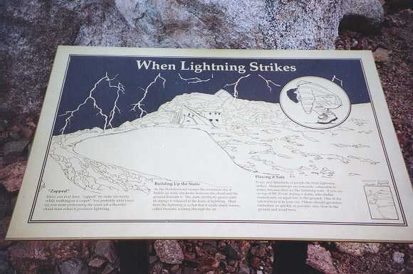
For the "gasoline climbers" and novice alpine hikers, this plaque tells you what to do to avoid being fried to a crisp by lightning. Lightning is a serious danger above treeline and especially near the summit of these peaks.
 |
At the summit, the roofless ruins of the restaurant and gift shop have been turned into a "museum" of sorts. Displays like this one show the history of Mt. Evans Road and the area. Even though the building has no roof, it was a nice haven from being blown away by the howling wind up here.
 |
The actual summit of Mount Evans is a few feet above where the parking lot sits. Here is a picture of the rocky peak. Hmmm, I wonder if they'll change the elevation of the mountain if I stacked a few more rocks up there...
 |
Is this thermometer right? It's only 50 degrees up here? It feels much much colder with the wind. Shortly after taking this photo and having a short snack from my cache of food in the backpack, I entertained thoughts of hitching a ride down with one of the tourists. I was tired and the weather was taking its toll on me.
Had I came up from the Summit Lake area instead of Guanella Pass, I surely would have given in to my temptations. In order to drive to Guanella Pass where I started, you'd have to descend the paved road to Idaho Springs, drive west on I-70 to Georgetown, and then drive up another dirt road. So I couldn't justify asking a tourist for that favor. Although, a fellow hiker on that day did exactly that. Interestingly enough, he was the only hiker I've met on this trip who had bagged all 54 of Colorado's fourteeners.
 |
Coming down Evans was pleasant (up to a point). Instead of going back across the Sawtooth Ridge, I used another route that ran next to Mount Spalding and came around the south side of the Willows. Descending this "trail" was nice because I didn't have to go up to the summit of Bierstadt again. It was a gentle slope opening down to a stream and a green mountain oasis. Along the way, there were no other hikers. It was just me, the mountains, and these gorgeous wildflowers. Very serene and peaceful...
Little did I know at this point that the innocent looking green bushes (willows) you see on top of the berm would make my life a living hell in the next couple of hours!
 |
The torture began near the left edge of this photo where I came down from Evans. As I got to the flat marsh you see before you known as the Willows, the bushes got thicker and thicker. At points they were 8 feet tall, and the only way I could advance is to raise my arms high and push forward with my chest. This of course awakened millions of aphids clinging to their branches. I must have inhaled at least 20 of them. Yuck.
The ground (if you can call it that) was soggy and spongey, and my feet sank down with every step. The mud was a nice black color and not too fresh smelling. Weary of quicksand, I resorted to using the branches of the bushes I displace as stepping stones to avoid sinking into the mud any more than I had to. As it was my shoes were pretty well soaked by the time the 2-hour ordeal ended. Fortunately for me in the few clear spots I chanced by, I could see the top of Guanella Pass where my travails began this morning. Otherwise I might have gotten lost in this quagmire.
The sticks you see in the photo mark the much welcomed end of the Willows and the edge of the Guanella Pass road. Thankful that through all the bush whacking I emerged close to where I began, I was both relieved and worn out at this point. One last photo of the mountains I had just conquered showing Bierstadt and the Sawtooth before I dragged myself the last 500 feet up the road to my car.
 |
I've melted!! (Just kidding.) I was all too happy to remove my armor after the marsh. They actually looked a lot better than I thought. Just some wet shoes and a few spots of mud on the sweats. 'Course I had already shaken off by then the thousand or so aphids that wanted to take up residence on my sweatshirt. Mental note: next time, take the Sawtooth and Bierstadt on the way back!
The good news after such an ordeal is that I got to celebrate with fervor. In charming railroad town Georgetown at the base of Guanella Pass, I stopped at a small souvenir shop and soda fountain called the "End of the Line". Although I couldn't find any commemorative shirts for Evans or Bierstadt, I did find a very large and very delicious milkshake and a great conversation with the shopkeeper whom I'll call "mermaid." (Mermaid, if you are reading this, thanks again for an awesome time!)
Back in Denver, I got a much needed hot shower and found a delicious hot meal waiting for me. Coupled with a few microbrews brought back from Estes Park Brewery the day before and some great company, the day ended on a high note. Needless to say, I slept like a log that night!
 |
| Prev | Next | Index |