 Eighth Annual Grand Canyon Hike (2003)
Eighth Annual Grand Canyon Hike (2003)
 |
Eighth annual Grand Canyon Hike -- May 3, 2003. Several notable events set this year's hike apart from the previous ones. The most dramatic of which is the hail and snow storm that passed through the campground just after dinner. Quite an interesting experience to say the least.
Let me back up a little and start from the beginning... The trip started innocently enough this year. I planned it in March and wanted to go in early May in an attempt to lower the hiking temperature. The past few years we've seen temps near or over 100 degrees at the bottom, which really takes quite a bit out of the hikers. So the early start theoretically would help that situation. Little did I know, the El Niño year coupled with an untimely cold front made the weather at the top a little "unruly". The forecast a couple days before we left Phoenix called for rain and wind, but unfortunately we were already committed to this date. So off we went!
After peaking at 44 at one point, the final count ended up at 34 participants and 17 "full-enchilada" hikers. The 34 participants is a new record, narrowly beating the 33 from last year. (Actually, if you want to be picky, I can claim 34.75 participants. I'm counting my 9-month old niece as 1/2 a participant and Jennie's soon-to-be newborn as 1/4 since neither of them are old enough to make a conscious decision to be a part of my madness.)
A couple other firsts on this trip. We were allowed to have ground fires for the first time, which is a big help with the camping experience. Unfortunately it made the cooking awkward since they did not provide us with the usual stand-up charcoal grills. We had to make do with the firepit grates. Also, this is the first year I brought a digital camera to capture the scenery. I'm using a Pentax Optio GS330 3-megapixel camera. The images you see here were captured at 2048x1536 and reduced down to 600x450 for easier viewing. Finally, this is also the first year we had multiple FRS walkie talkies along with us. I was amazed at the range in the canyon. We could communicate with someone at Mather Point or Bright Angel trailhead most of the time throughout the entire hike! This is a must have for all future trips.
I'm also going to describe the "routine" in more detail throughout these next frames so as to capture more accurately the entire hiking experience. If any of you wish to do this in the future, it might help you to gauge the effort. So without further ado, here we go for #8:
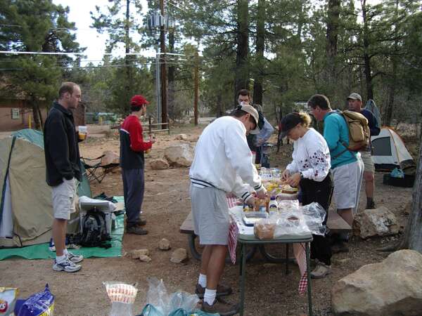
The alarm was set for 5:55 am, but I awoke around 5:30. I can't help it. This trip always gets me pumped up. So I get up and tend to the breakfast buffet. Dragging out all the juice, milk, cereal, pastries, fruit, and of course, the peanut butter and jelly sandwich manufacturing station. You see, PB&J is the perfect food for long hikes, and without it we'd all be in big trouble. In the early years, I'd make all the sandwiches, but after the hiker count exceeded 5-10, it was nearly impossible. So we have a PB&J assembly line like the one you see in this photo.
Most folks roll out of bed around 6:30 am. The air is a chilly 35 degrees, and our fingers don't work too well. Some folks brought camping stoves and heated up some water for a hot drink or two. Others sipped the OJ and munched on some pastries and bagels for breakfast while building their ration of PB&Js.
 |
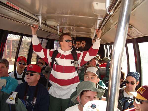
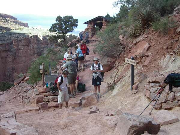
It takes another 1/2 hour or so to get everyone rounded up. At 7:30, we head out in several vehicles toward Mather Point and the Canyon Information Plaza just across the street. The bus to the South Kaibab Trailhead leaves from there. The trailhead is not accessible any other way, so we are forced to take the shuttle. The drivers leave their vehicles at Mather Point, and we all file into the shuttle bus. Upon return, the drivers will have to take the Village Loop bus from the Bright Angel trailhead back to the Canyon Information Plaza to retrieve their cars.
Today, we have a record number of people on the bus. As you can see, standing room only. I've never seen so many hikers on this bus before. You can see Jim in the light blue sweats on the left. Behind him in the white T and red hat is my brother Shaung. Martin hangs on for dear life in the aisle. Judging by Dan's bulging eyes, he was surprised at something in the front of the bus. We also have Bill in the green hat, Kevin in the blue bandana, and Brock in the ASU hat. Notice everyone is in great spirits still.
 |
A short 5-10 minute ride later, we arrive at the trailhead. Since everyone has a different speed on this hike, this is the only chance we'll get to take a full group photo. Here's also where I try to lecture everyone on the gotchas on the hike, and how to get back to the campground once you get to the top.
From left to right, we have Martin, Ric, Nancy, me, Ryan, Mandar, Shaung, Kevin #1, Bill, Steve, Brock, Angie, Dan, Cliff, Kevin #2, and Mark. George is wielding the camera (or I should say being innundated with a barrage of cameras from the group). The only person missing from the photo is Claudette, who we later found out had already started down the trail. This is about 8:15 am.
 |
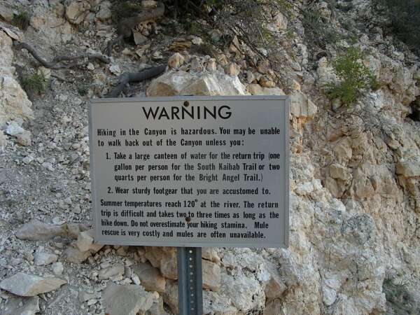
As you start hiking down along the South Kaibab, you'll notice several warning signs advising you of the dangers involved in Canyon hiking. It seems like there's a new one every year. I make it a habit of taking a picture of all of these "death signs", so named due to the dire warnings of death and destruction that will befall those who attempt to go to the iver and back in the same day. I think this one is new this year.
 |
As you hike down the switchbacks, you'll be amazed at the view of the North Rim in front of you. You'll be disgusted by the none-so-fragrant mule droppings and puddles. And you'll be thinking what am I getting myself into?
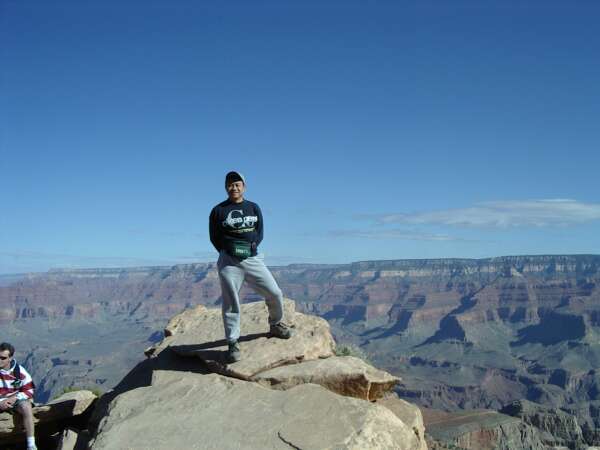
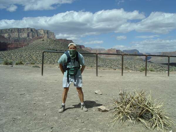
The first notable landmark along the trail is called Ooh-Aah Point. It's unmarked, but unmistakable. At one point the trail makes a 180-degree turn, and at the point you'll enjoy an unobstructed view. Here I am at Ooh-Aah Point trying not to get my hat blown off by the brisk wind. I'm sporting my lucky Pikes Peak sweatshirt, which you'll see me wearing in a lot of these hiking photos. Don't worry, unlike some baseball players and their lucky hats, this sweatshirt sees the inside of a washing machine every time after a hike.
 |
Descending some more along the South Kaibab trail, you'll come to a wide open area with reddish dirt. This photogenic area is called Cedar Ridge. I'm not sure if there are any real cedar trees here, but it is a nice rest stop. This is also where you'll find the first toilet.
If you come here after Memorial Day, you'll likely encounter a park ranger here who will do his/her best to dissuade you from hiking to the river. This is the spot where we learned of our canyon hiking mantra from the friendly neighborhood park ranger: "Remember, eat before you're hungry. Drink before you're thirsty. Because if you're hungry or thirsty, it's too late. You've blown the power curve!"
After many canyon hikes, I've found this motto to be very true.
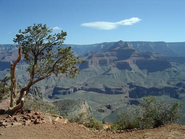 |
The trail descends more gradually after Cedar Ridge. You'll encounter fewer switchbacks and walk along a nice ridge and open area. It's a great place to take your eyes off the ground in front of your feet and enjoy the view. You'll likely see several unmistakable stalks of century plant (agave) blooms, and many purple blooming beavertail cacti.
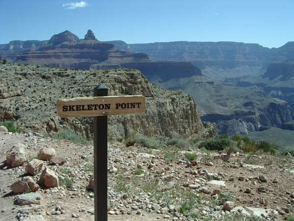
The next point of interest is Skeleton Point, which is the recommended turn-around point for a day hike down South Kaibab. There's not much here, just a hitching post for mules. I certainly didn't see any skeletons. I wonder how it got its name. Perhaps there was at one time the skeleton of an unfortunate hiker found here. The new sign marks the spot.
 |
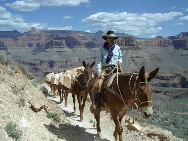
I always get mixed feelings when I see a mule train. They have been a part of the canyon transportation system since the beginning, so they belong here. But every time they pass, I wish they weren't there. For one thing, they smell. They also kick up a lot of dirt and dust. Then, you have to step off to the side to wait for them. Sometimes you'll get stuck next to a tour guide on a mule giving a 10-minute speech and have no way to pass them.
But I do appreciate what they do for Phantom Ranch. All provisions, mail, and trash are transported on mules. This fellow is escorting a load of US mail from the bottom. If you do get a chance to visit Phantom Ranch one day, don't forget to send a postcard from there. Your friends will appreciate it. If you don't have any friends, send one to yourself. It's worth keeping as a memento.
 |
Grrr!!! Charles the bandit growls. The bandana came out after a surprise gust of wind coated my teeth with a layer of fine canyon dust.
I'm standing in front of a mule hitching post at the Tonto Trail junction. The Tonto Trail traverses the Tonto Plateau, a relatively flat mesa about half way down the canyon. You can take the Tonto trail from here all the way to Indian Garden on the Bright Angel trail. This crosscut eliminates about 35% of the elevation gain on the hike, but it adds about 5-7 miles to the hike. There's also no water along the Tonto Trail, so I normally don't take it. If you do want to take the crosscut, look for the sign for Tonto Trail carefully. It can be easily missed.
At this trail junction, you'll also find another toilet. I consider this the point of no return along the South Kaibab trail. You have come 4.5 miles from the top and dropped 3,200 feet of elevation. If you go any further, you might as well go all the way down. The Bright Angel trail (although longer) provides more rest stops, more shade, and several water sources along the way up.
 |
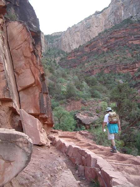
Shortly after the Tonto Trail junction, you'll come to another unmarked vista point. This is the Tipoff. From here, you can look down and see the switchbacks of the trail and get a glimpse of the Colorado River at the bottom of the canyon. Here I am taking a quick snapshot.
You'll notice my usual hiking gear, effective if not stylish or efficient. The hat worn backward to protect the back of the neck, bandana to filter the incoming air, daypack with chest clip and waist straps, fanny pack for frequently used items such as my camera and binoculars, and a 1.5 L bottle of water to round out the uniform.
 |
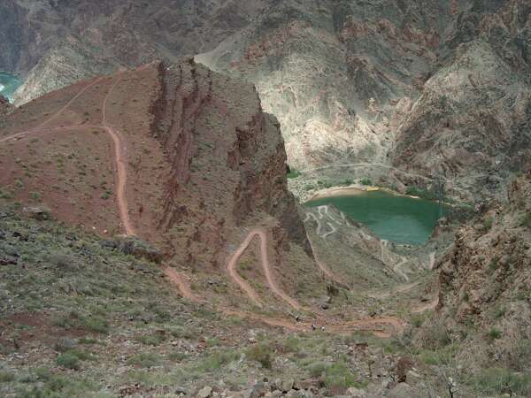
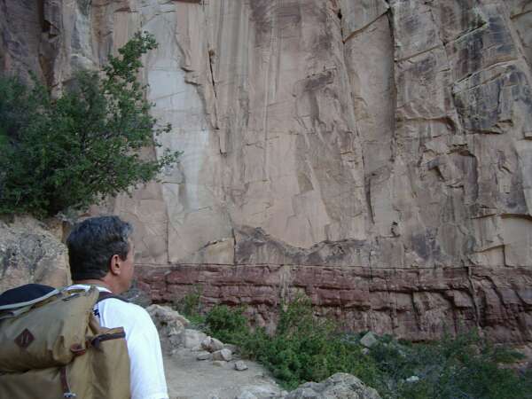
This vantage point is quite scenic. You can clearly see the switchbacks along the rest of the South Kaibab. The formation on the left is the Panorama Point. You can just make out the tunnel and the black bridge crossing the turquoise waters of the Colorado River.
 |
After having a snack at Panorama Point, we descend into the depth of the canyon. Rocks seen here are some of the oldest in the canyon. Here's a view of the black bridge, the first bridge we encounter on this hike. The trail takes you through a long tunnel and then onto this bridge, a sure sign that you've arrived at the bottom of the canyon. Now you just have to focus on getting out.
 |
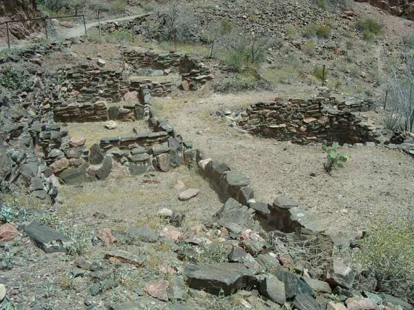
Along the north beach, you'll find the ruins of a community built by the Anasazi Indians around 1060. John Wesley Powell noted this find in his journals as he explored the Grand Canyon area in 1869.
In another hundred yards, the South Kaibab trail comes to a T with the Bright Angel trail and the North Kaibab trail. This is the crossroads of the canyon, the meeting place of all three major trails. It's also a great place to soak your aching feet in the cold water of Bright Angel Creek. Take care not to get your shoes or socks wet, as hiking with wet footwear causes severe blisters. As a matter of fact, this is a great place to change into a fresh pair of socks for the hike out.
If you choose, you can hike another 10 minutes to the snack bar at Phantom Ranch. This is a little out of your way, but it's worth a visit if you haven't been there. They have a small selection of gift items, some food and drinks, and a nice place to sit and have your lunch. After lunch, write a postcard to your family and put it in a leather pouch on the wall (mailbox). Then, relax and have an ice-cold lemonade.
 |
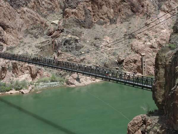
After lunch, you backtrack to the junction of the trails, and head toward the Bright Angel trail. This will take you across the silver bridge and back on the south side of the river. The silver bridge has a see-through bottom, so look down and get a nice glimpse of the rushing water below you (unless you get vertigo easily).
After the bridge the trail snakes along the river for about a mile. It's one of my least favorite sections of the trail since you are walking in deep fine sand. On hot days, the heat really seeps into your shoes. Hiking in sand also makes you tired due to the sinking effect. However, it does offer a nice view of the river. Here's a shot of some beavertail cacti in bloom along the side of the trail. You can see the Colorado River below.
 |
The trail finally leaves the river and turns toward the south rim. Garden Creek runs alongside the trail and offers hikers a refreshing dip of the shirt or hat on hot summer days. The stretch of trail between Phantom Ranch and Indian Garden is the longest uphill section on this loop without any drinking water. Though tempting sometimes, the water in Garden Creek is not drinkable. For this reason, I recommend you carry at least 3 liters of water on this hike.
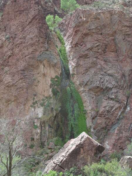
At one point on the trail, you'll see a tall waterfall on the cliffs to the west. This waterfall becomes just a trickle in dry years, but today there's actually some water in it.
 |
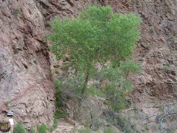
Soon after the waterfall, you enter into a series of steep switchbacks called the Devil's Corkscrew. It's the first steep section you encounter going up toward the South Rim. If you aren't used to this hike, it can be pretty daunting, especially when the weather is hot. There's very little shade on this section, and you've left the cooling waters of Garden Creek for a while. But just when you thought all hope is lost and you might end up as vulture feed, the switchbacks give way to some gentle straights, and you come upon the "Tree of Life". This lone cottonwood is a great place to take refuge and a well-deserved break.
 |
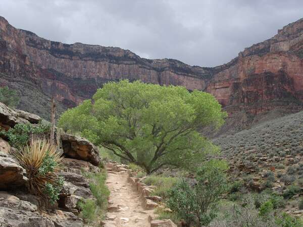
The trail climbs gently upward some more, and soon you'll come to the same level as the Tonto Plateau. You can mark your progress by watching the side of the trail as it slowly pulls even with the plateau. Garden Creek has returned to your side, offering another cool shirt-dipping. Off to the left, you'll see where the Tonto Trail joins in. (Remember where it meets the South Kaibab trail?) Once you pass the Tonto Trail junction, you'll find Indian Garden, an oasis that offers rest, drinking water, shade, and a ranger station should you need help.
This is my favorite tree in the canyon, a giant cottonwood rooted next to the stream bed below the trail. Its canopy comes up next to you as you walk toward Indian Garden. I always know I'm getting close when I pass this tree, so it has a soothing psychological effect too. At this point, you can see the end of the hike, though still quite far away. You'll eventually top out at the "v" above the right edge of the tree.
 |
After a proper rest at Indian Garden, some more food, and another change of socks, we head out for the second half of the Bright Angel trail. This last 4.5 miles can be divided into 3 sections. There's water available every 1.5 miles, so you can reduce your pack weight by keeping only 1 liter of water.
The first section is a gentle approach to the canyon wall. It's somewhat discouraging to look up at this point, so keep your eyes on the trail. The 3-mile resthouse marks the end of the first section. Unfortunately, you still have the toughest part of the hike ahead of you. Today, we're sharing the rest area with a bunch of Wisconsin school kids on a field trip.
 |
The canyon squirrels are not shy about coming right up to you to ask for food. If you are not careful, they'll go right into your pack while you are up getting some water. This fellow wanted some of my granola. It's against the law to feed them, but how can you resist such a cute face?
 |
The rest of the hike is a series of killer switchbacks. They seem to go on forever. The fact the toughest part is at the end is the reason why so many people get into trouble in the canyon. They are ill-prepared for the effort it takes to dig themselves out. My best advice is to go at your own pace, and just keep your head down, put one foot in front of the other, and whittle it down one step at a time.
Jim walks on the edge of the trail to avoid some deep ruts.
 |
When you take a break, don't forget to turn back and look at how far you've come. You get a whole new appreciation for the grandeur of the canyon when you've climbed out of it. This picture was taken near the 1.5-mile resthouse. The clouds really bring out the magnificent scenery in the canyon. In this photo, you can make out the green oasis of Indian Garden, the Plateau Point trail on the Tonto Plateau to its left, and the canyon directly ahead where the North Kaibab trail ascends to the North Rim.
 |
Soon after the 1.5-mile resthouse, you will climb out of the red layer. It's another mental victory because the yellow layer is the top most layer. Jim comes to eye-level with the transition between the layers here.
 |
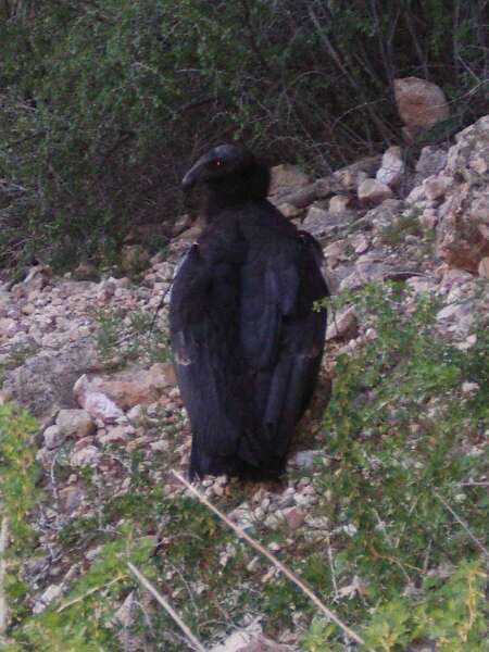
Today we are lucky enough to pass a California condor resting just off the trail. These endangered birds roam the canyon, and they are often tagged. This fellow wore #95 just under his right wing.
 |
The last 1.5 miles of the hike seems like 2.5 miles. There are ways you can gauge your progress though. There are 2 arches you must pass. The first one is about 3/4 mile away from the top, and the second one is pretty much right at the finish line. You'll go up some more switchbacks, but eventually you'll come to a long straightaway. This is another sign the trail is about to end. Once the trail straightens out, you'll have one last turn toward the left. Then it's another gentle but long straight all the way to the top.
Jim raises his arms in victory (or is it surrender?) as we reach the second and final rock arch. You've made it! Congratulations Jim. What a great feeling to reach the top! Don't forget to stop at the Bright Angel Lodge where you can get a scoop of celebratory ice cream and look out at the day's accomplishments.
 |
After the hike is over, you can catch the Village Loop bus right next to the trailhead. This bus will take you (after several stops) back to the campground or to the Canyon Information Plaza to retrieve your vehicle. Be warned though, the bus only runs until 1 hour past sunset.
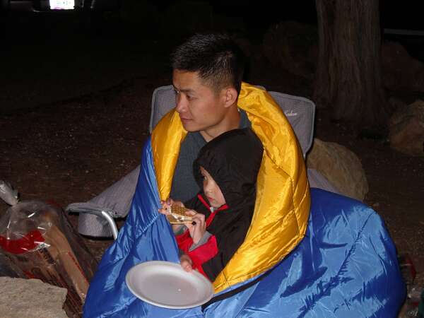
Today was exceptionally cold at the top. I doubt the temperature ever got above 55 degrees. As night fell, the temperature kept dropping, and put a damper on our dinner festivities. We were lucky though, everyone finished their dinner, showered, and had a chance to enjoy a s'more or two like my nephew Carter here.
Unfortunately, soon after dinner the skies opened up with a hailstorm, followed by about an inch of snow. Those of us who tried to stay up and wait out the storm got soaking wet. Well, I guess it was a hint to go to bed early. Inside the tents we bundled into our sleeping bags and slept soundly until the morning.
This wraps up another Grand Canyon trip. Hope you've enjoyed it as much as I always do. Can't wait to find out what kind of surprises next year will bring. So until then, happy trails.
 |
| Prev | Next | Index |