 Mount Rainier (14,411 ft), Longmire, Washington
Mount Rainier (14,411 ft), Longmire, Washington
 |
| Hike Stats | Date: June 22-23, 2005 | |
| Mount Rainier: 14,411 feet | Base: 5,411 feet | Vertical Rise: 9,000 feet |
| Start: 08:20 | Summit: 11:24 + 1d | Return: 19:50 + 1d |
| RT Dist: ~21 miles | Conditions: Day 1 - whiteout, Day 2 - sunny | |
I've seen it many times, looming over the shoulder of Seattle's skyline -- a hulking mass of ice and snow that is as tempting as it is forbidding. I'm talking about Mount Rainier of course. It's the only fourteener in Washington, and a magnificent volcanic glacier that never melts. At 14,411 feet in elevation, nothing around it comes even close in height. I could just imagine the views from its summit.
My chance came when a friend of a friend began to organize a trip to climb Mt. Rainier. Of course I had to jump at the opportunity, but deep down I was worried about my lack of glacier experience and lack of equipment. Afterall, I am a desert dweller. What do I know about ice and snow and glaciers? The thirst for fourteeners must be quenched, however, so off I went on a shopping spree for gear and a fit of binge-training. Dealing with the logistics of making airline and hotel reservations, reading about glacier traversal techniques, and gathering (borrowing) the appropriate climbing equipment slowly solidified the trip in my mind. Day by day, it was becoming more real and more imminent.
Preparations were going smoothly, and I was growing more excited by each passing day. About 2 weeks prior to our trip, bad news struck in the form of an article detailing the untimely death of two people on Rainier, on the very route we were about to take! Apparently two men froze to death while descending from a weekend trek to Camp Muir, which is only about half way up the mountain. Still, I was not deterred. It appears that they had all the right gear but just didn't use it. I dismissed this incident as a case of stupidity and resumed my training.
Then, one week before our planned trip, another news item hits. A climber fell to his death on Rainier. This time, it struck a nerve with me. This guy was a firefighter and a seasoned climber, someone who knew what he was doing. Yet, he fell 800 feet down a steep slope! I was beginning to worry. On top of that, my knee was slightly injured on a training hike, adding to the apprehension.
The odds are still with me, right? After all, the mountain God claims only 3 lives in an average year, and thousands of people reach the top. Folks seemingly less capable than I make it all the time. I've heard tales of young and old, including some who lack a limb or two, summitting Rainier. If they can do it, surely I, the Mad Hiker of sound mind (OK, no comments please) and able body, can pull this off! Right? Right!! So with a heightened sense of respect for the mountain, I gathered my gear and boarded an airplane to Seattle...
The rest of this story is being told via a photo journal hosted by KodakGallery.com. When you are finished with those photos, return to this page to continue browsing other hikes.
| Photo album on KodakGallery.com... |
| Mountaineering ascent of Mt. Rainier (14,411 ft), the tallest point in Washington State and a perennial glacier peak. | ||||
|
2005-06-23 Mt. Rainier
(1 album) | |||||
|
If you can't see the link, copy and paste the following directly into your browser:
http://www.kodakgallery.com/I.jsp?c=mvhmxg7.9onso1q3&x=0&y=ifl9du
Questions? Visit http://help.kodakgallery.com.
|
Welcome back! Now that you've read the full story (hopefully), you might be interested the following photos:
As a reference for the route we took, this is a scanned topo map of the area. We ascended the "Muir Snowfield" and then went up the "Ingraham Headwall".
 |
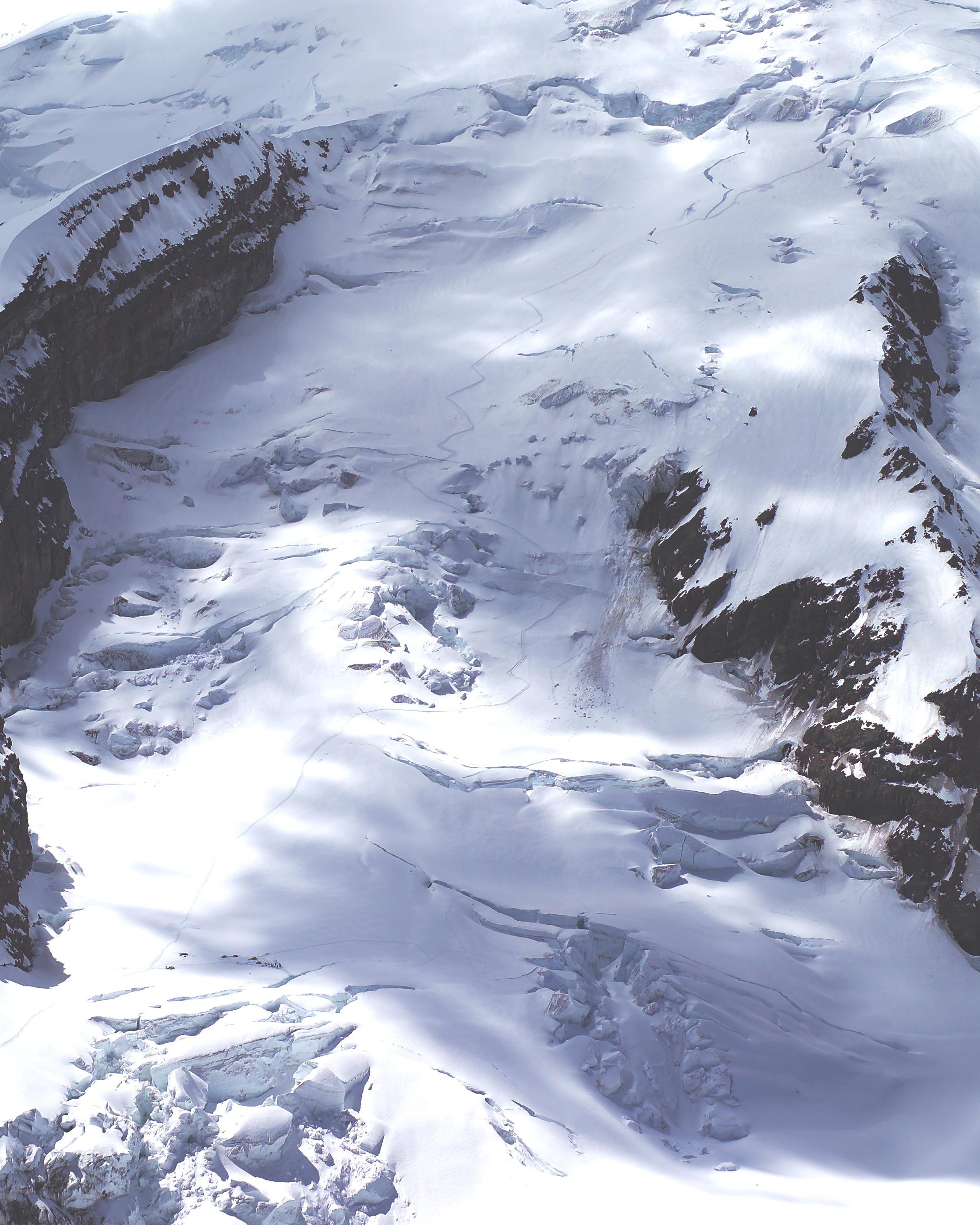
This is an aerial photo of the Ingraham Glacier taken 2 days before our climb by Mike Baum of Vantage Point Photography. He was also one of the members of my rope team. You can see the Ingraham Flat camp at the lower left of the image, as well as most of the route in the glacier's ablation zone. Note the avalanche near the Disappointment Cleaver rock wall and all the crevasses throughout the glacier.
 |
| Prev | Next | Index |
