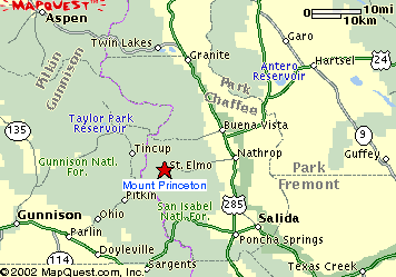
 Mount Princeton (14,204 ft), Nathrop, Colorado
Mount Princeton (14,204 ft), Nathrop, Colorado
 |
Journal of a Mad Hiker (Part 2, continued)
| Hike Stats | Date: September 4, 2002 | |
| Mount Princeton: 14,204 feet | Base: 10,820 feet | Vertical Rise: 3,384 feet |
| Start: 08:00 | Summit: 11:00 | Return: 15:00 |
| RT Dist: ~8 miles | Conditions: sunny with afternoon storm | |
Mount Princeton sits majestically in the Sawatch Range. Like its Ivy League cousins in the Collegiate Peaks (Harvard, Yale, Oxford) and other Sawatch brethren, Princeton is a massive monolith with fairly gentle nontechnical approaches -- ideal for hikers like me. The reason I chose Mount Princeton first over some of the others is its proximity to the heavenly Mount Princeton Hot Springs Resort. The resort itself is nothing fancy, but to a pair of tired hiker feet and a sore hiker body, the hot springs bring almost unparalleled relief.
After sauntering around South Park, I decided not to return to my home base near Denver and to spend a night in the mountains. This will eliminate my commute the next morning and give me a little more time to explore the region. First order of business was a soak in the hot springs of course. Oh that felt soooo good. The 105-degree water seems to melt all the knots that accumulated in my muscles after a day of hiking. It also seems to make me lighter and my breathing easier. What a great feeling.
The dinner at the resort rivals any restaurant meal I've had, or perhaps it's the "everything tastes better when you're starving effect." Nice ambience too. I sat with a view toward the hills through a large window, watching the afternoon storm roll through the mountain, studying my Dawson's Guide, and mentally planning the day's hike tomorrow. After dinner, I sat by the fireplace to read some more and enjoyed a nice local microbrew.
You might think I would have just splurged and stayed at the resort, but not so. I'm way too cheap to do that. Instead, I camped out in the forest near the trailhead. There's something to be said about roughing it though. The morning chill when you wake up at sunrise... and the feeling of warmth seeping through your body to the fingertips and toes as you sip a hot tea (I don't drinik much coffee) prepared on the camp stove... Watching the orange sun peek over the eastern horizon through the steam rising out of my cup... Playfully blowing a plume of mist in the cool morning air. A nice start to the day I thought.
The Mount Princeton Trail follows a 4x4 road for 3-4 miles to an array of radio towers and continues for a mile or so before branching off for an additional 3 miles to the summit. I worried about the length of this hike the night before and decided to try the road in my dutiful subcompact to see how far I would get -- apparently not very far. About 1/4 mile into the drive, I saw some ruts the size of which intimidated me. So I let my car roll down the hill (no place to turn around) back to the parking lot. Good thing it was early enough that no other cars were around. As I found out later, a different guide book pointed out that you'd better know what you're doing getting on this road because you simply can't turn around! Chalk one up to luck I guess.
Just as I felt all dejected at the prospect of hiking an additional 3 miles along a dirt road and having to gain 2,400 extra feet of elevation, my luck kicked in again. A Nissan Pathfinder rolled to a stop next to me in the parking lot as I was "gearing up." Two friendly smiling faces greeted me and I soon realized that they belonged to David and Rafi, two hikers I had met the day before on the summit of Mount Bross! What are the chances of that happening?!! I gladly accepted their offer of a ride to the radio towers where we began our hike for the day. David lives in Colorado while his Israeli friend Rafi lives in the bay area. Every year around Labor Day, they get together to do a few fourteeners. Sounds like a great idea to me! I might make this week long trip an annual event, too.
We plodded along the trail together at first, but I soon pulled away from them as I found my "zone." This was an amazing day -- the only time during my hikes that I saw no other people along the trail from when I left David and Rafi all the way to the summit. I felt completely peaceful and involved with my surroundings. But wouldn't you know it, my "involvement" became a little too intimate as I took a pretty hard 4-foot fall along the trail as I tried to skirt a large rock in the way. The damages were a deep laceration on my right pinky knuckle, a cut on my right shin, and a very sore right butt cheek. To borrow a skiing term, it was one of those "yard sale" type falls where I just lost it all. Good thing (or bad) that I landed partially on John's digital camera, which suffered another crack on the display, but probably saved me from further injuries.
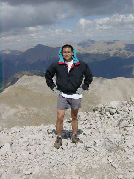
A little embarrassed about the fall and thankful that no one was there to see it, I righted myself and tended to the wounds as efficiently as I could. One of my three water bottles also fell victim, so I drank as much water out of it as I could and managed to save the rest by carrying it upside down the rest of the way to the summit. I made good time and reached the top by 11:00. Not another person in sight. The only sound is the wind whisking past my ear. A lone eagle's cry would have completed the picture of solitude for me, but no such luck. I signed the summit log and ate my picnic lunch -- a diet of power bars, bananas, and beef jerky.
The predictable clouds are building overhead by now, but I saw David and Rafi coming up the slope toward the summit, so I decided to wait for them. It's getting pretty cold as the wind picked up speed. I had to pull out the gloves. One of the problems of hiking alone is the lack of a photographer. I tried my best to get a picture of me in the standard victory pose at the summit, but didn't do too well. So waiting for them had the added benefit of ensuring a summit picture. Mental note: buy a small tripod for the next hike. They reached summit shortly after noon, and I started back down shortly afterwards.
The descent can only be described as a mad dash for tree cover. The clouds have covered the sky by now, and distant thunder rolled in. I ran along the trail at the edge of the shadow cast by the incoming storm, racing the weather. The freezing rain caught me just as the trail joined the old jeep road near tree line. Whew. That was close! Even though I was prepared with rain gear, I didn't relish the thought of hiking in it. Fortunately it wasn't too bad, just a notch above drizzle and a notch below steady rain. I slowed down after tree line, and proceeded to hike down the road toward the parking lot. The extra 3 miles went fairly quickly, and by 15:00 I was back at the car, looking forward to my dip in the hot springs.
 |
 |
 |
 |
 |
 |
 |
 |
 |
 |
 |
 |
 |
 |
 |
 |
 |
 |
 |
 |
 |
 |
 |
 |
 |
| Prev | Next | Index |